


 |
 |
 |
 |
|
|
|
Walking & Driving Tours |
|
MASSACHUSETTS - Self-Guided Tours #1 - Indian Mounds: Maudslay State Park, Newburyport, MA |
|
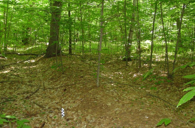
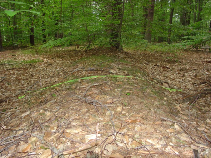
Who Built the Mounds? The state park’s archaeologist accompanied the author and her research partner on a site walk. During the site walk, several potential explanations for the feature were considered including 20th century landscape associated with the former Maudslay estate, and ha-ha fences to fence in livestock. Both of these explanations were rejected. At the conclusion of the site walk the state park’s archaeologist hypothesized that the feature may be a Native American earthwork [mound] given its close proximity (1 mile) to a confirmed Native American mound. (Morrill Point) |
 |
|||
 |
|||
|
History of Area Shards found on the Main Road on the outer edge of the mounds show there were several early houses in the area. In Sawyers Hill Burying ground adjacent to the parking lot the gravestones of the early settlers can be seen. The Arrowhead Farm property abuts the ferry road and park property on the side where the mounds are located. The state park guide says the area near the ferry road was the “site of early Native American settlements”. The Maudslay family acquired the lands abutting the river from 1860 to 1900. More land was added in 1920. They created a large country estate where they came on weekends and summers. (Maudslay State Park brochure) How to find the mounds The mounds are located in the pine grove number 14 on the state park tour guide map. To get to the pine forest from the parking lot, use the gate/entrance across from the pay station. Cross the road to the large open field through a narrow opening in the stone wall. The narrow foot path immediately splits, take the path leading off to the right, the other path goes straight and leads to the Pasture Trail. The path takes you out to the pine grove (forest). The narrow foot path turns into a dirt road. Shortly after you enter the forest a path comes in from the left, keep straight walk on until you come to a second road entering from the left. Walking time from parking lot to second road on left is approximately 10 minutes. Take a left onto the dirt road. An earthen mound parallels the dirt road. Look to your left, at first the mound is hard to see, but as you walk further down the road the mound and ditch is better developed and easier to see. Towards the end of the road the mound angles off away from the road. To see the end of the mound, take a left onto Overlook Road. It is a short walk on the Overlook Road. The pine forest was planted it is not a natural forest. Note a few pine trees were planted on top of the mound. I wonder if the men planting the trees were aware of the earthen mound. Most of the trees are not planted on top of the mound but beside the mound. This is the only mound along side a trail/road. To see more of the mounds and an interesting kettle hole, turn around after you find the end of the mound and head back to number 13. A trail circles around the kettle hole. Across from the kettle hole is a road leading off the main road. Walking a short distance you will come upon the ends of three mounds. The road cuts through an intersection in the mounds. The three separate segments of mound once converged here. At this point the mounds go into the woods. Walk the road out to the next road called the Fire Road at the T junction. Take a left on the Fire Road shortly you will come to two mound ends where the fire road cuts through a long segment of mound. Walk the Fire Road out to the Main Road (a dirt road). Take a right on the Main Road and go up the hill. At the top look for the end of a mound on your right. This is the terminus of the mound segment. To get back to your car and parking lot continue in the same direction on the Main Road. This will bring you out the dirt road that parallels Pine Hill Road. Take a right at the end and follow the dirt road back to the narrow foot path across the field. To explore the park further, use your park trail map. The mounds are a rare Native American Indian feature in the New England landscape. The mounds escaped destruction during the last 400 hundred years except for road cuts. Please continue to preserve for future generations. The design of the mounds indicates they were ceremonial. Look and ponder what ceremony might have taken place? Park Rules Information in Tour Guide To Learn More about Native American Indian Ceremonial Structures in New England checkout: A Handbook of Stone Structures In Northeastern United States Directions to Park From West (I-495): |
|
|
 |
|
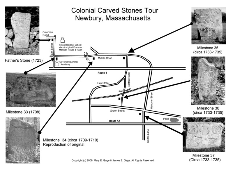
The Newbury Carved Stones A total of 10 carved stones from the colonial period have been found in Newbury, Massachusetts. Six of the stones can be still seen in Newbury. The other four are in the Smithsonian Museum of American History. Father’s Stone (Coleman Road) This stone was originally found on the Dummer farm, now the site of the Triton Regional School. The Dummer family was one of wealthiest families in the 1600 and 1700’s in Newbury. The stone was removed to its present location in the 20th century. It is known locally as the “Witchstone.” A name derived from the idea that the circle designs were thought to be hex symbols. The circles and triangular are actually common decorative geometric designs popular in their time period. The stone features a full length caricature of a man in late 1600’s fashionable clothing which includes a long waistcoat and high heel shoes. The hands are on the waist and the feet point outward, a common pose used in folk art from the 1600’s through 1725. The stone was commissioned by John Dummer as a memorial to his father Richard Dummer Jr. It was used as a walkway stone leading to the family mansion house. It was carved in 1723 by Robert Mullicken, Sr. a gravestone carver from Bradford, Mass. Milestone 33 (Gov. Dummer Academy) “B 33” stands for 33 miles to Boston, “N 5” stands for five miles to the center of Newbury which was near the 1st Parish Burying Ground at the time. The stone was commissioned by John Dummer and carved by John Hartshorn, a local gravestone carver. Milestone 34 (Middle Road) This stone is a reproduction based on a surviving fragment of the original milestone currently in a private collection. It was carved circa 1709-1710. It is similar in design and basic layout to milestone 33 and several milestones on Rte 1A Wenham, MA. Milestones 35, 36, and 37 are the only known examples of milestones carved with bold geometric designs. All other surviving milestones from colonial America were carved with pertinent information and lack any real decorative embellishments. These milestones may have been commissioned for Newbury’s Centennial in 1735. Milestone 36 (Boston Road) The top section of this milestone was broken off. The missing section had a whorl (pinwheel) design. It also has a triangle within the design on the bottom. A triangle motif is found on all of the milestones commissioned by John Dummer. Milestone 37 (Junction of Green/Hanover St) This is the final milestone in the series. It has a double triangle design on the top and mileage to Portsmouth and Ipswich on either side. It was a family affair being carved by Robert Sr, Robert Jr., John, and Joseph Mullicken, all gravestone carvers. FOR MORE INFORMATION check out the book Stories Carved in Stone |
 |
|||||
 |
|||||
 |
|||||