


Pedestal & Perched Boulders
Pedestal Boulders and A Few Specialized Perched Boulders
By Mary Gage
New Materials added 9/9/06
Translated into Russian www.perpettum.narod.ru/USAboulders.htm
Pedestal boulders in this study are located in the following states: New Hampshire, Massachusetts, Rhode Island, Connecticut, New York and New Jersey. A pedestal boulder is defined by the boulder fully or partially raised off the ground on individual support stones. A perched boulder is defined by the boulder being placed on exposed bedrock, a layer of stone or on top of another boulder.
Two basic styles of boulder are seen in these categories: a thick, flat slab and a thick chunky boulder. The next layer sometimes applies but not always, it is the actual shape of boulder. Shapes that have been observed so far: rectangular, triangular, spherical, irregular. Boulders range in size from four feet high to twelve feet high. There may be some that are larger.
Some basic patterns have been noticed in various regional areas which occasionally cross current state boundaries. The listings are arranged by state from north to south. This set up allows for some continuity with the regional patterns. A full discussion of trackable traits and patterns is presented after the listing.
Location of pedestal and specialized perched boulders mentioned in this article. Gungywamp, America’s Stonehenge,
and Boston are listed for reference purposes only. They do not have a pedestal boulder feature.
New Hampshire
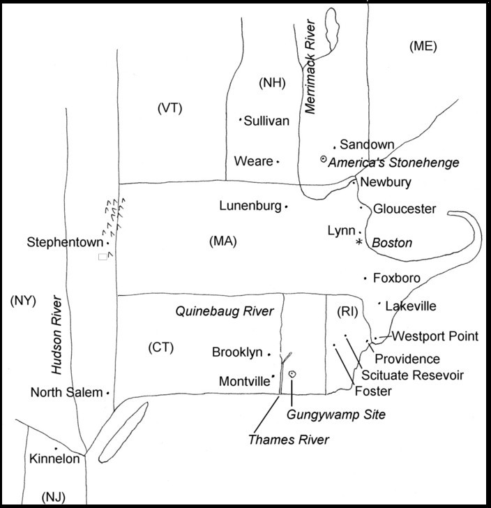
1- Weare (southwest): Full Pedestal boulder located on south side of Barnard Hill.
Information comes from Town History of Weare, N.H. 1888. The boulder has six support stones and weights 27 tons. (No photograph available only a line drawing)
2- Sandown (southeastern part of state): Supported-Perched boulder with an inverted triangular shape supported on each side by smaller stones. Boulder is shaped like an elongated prism with three sides. Boulder is located in an area with a summer solstice sunset alignment, a small cliff side chamber, a small cairn field and a much larger cairn field nearby. (Photo by author)
3- Sullivan (west-central on Connecticut River): Full Pedestal boulder on bedrock. An elongated oval shape on support stones (number not clear in photograph). Set up on a downhill slope with downhill end of boulder raised to a level position. Appears to have two support stones one on top of other at this end. (Mavor & Dix, 1989: 111)
Massachusetts
1- Newbury (northeast corner of state, coastal): Supported-Perched boulder with an inverted triangular shape set in a base boulder with a slanted side for support. This is a short boulder in the middle of a small specialized cairn field. Approximately one to two miles distant are larger groups of cairns with several enclosures. (Photo by author)
2A - Gloucester - Dogtown (northeast section on Cape Ann south of Newbury, coastal): Full Pedestal boulder on three support stones in a triangular pattern placed on exposed bedrock. Support stones are flat-top cobbles. Boulder has a rectangular shape. Two other perched boulders in close proximity form a triangular area. This creates a set of three specialized boulders. Nearby is small cairn field. (Photo by author)
2B - Gloucester – Dogtown: Partial Pedestal boulder on exposed bedrock a short distance from group of three (See 2A). Boulder makes contact with bedrock and has a single support stone. (Photo by author)
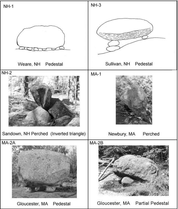
3- Lynn (northeast of Boston, south of Gloucester, coastal): Full Pedestal boulder placed on edge of ledge so length juts out past ledge. It has three support stones placed on exposed bedrock. Shape is rectangular. Shape and fact it juts out past edge of ledge has led to its common name “Cannon Rock” There appears to be an ex-large boulder directly on the bedrock behind the pedestal. Boulder is located in a residential neighborhood. (Cahill, 1993: 31)
4- Foxboro (east-central, interior): Partial Pedestal boulder appears to be on bedrock (unconfirmed). There are three support stones clustered together on one end. On opposite end there is a protruding knob on the boulder that was used to support it. This creates a four point support. (Rothovius, 1979: 34)
5- Lakeville (southeast): Partial Pedestal boulder with a concave underside. Boulder has three point support with two support stones and end of boulder on bedrock. Boulder was placed over an open fissure in the bedrock in which the boulder’s end was placed. (Photo by Bruce McAleer)
6- Lunenburg (north-central): Partial Pedestal boulder with three point support. It has two support stones and one end of boulder on bedrock. This is a thick slab with a triangle shape quarried and moved a few feet to edge of ledge. It was placed adjacent to a one and one-half foot fissure in the bedrock. Pedestal boulder marks east end of rocky hill. Two perched boulders mark west end of hill. One of the perched boulders has a spherical shape, other has a Y shape. There is a possible moonrise associated with this group of three boulders. (See Thames River Valley Connecticut for a discussion) (Mavor & Dix, 1989: 113-115)
Lakeville, Foxboro and Lunenburg each have one end of raised boulder in contact with bedrock as a support point called Partial Pedestals. Also, Rhode Island paratial pedestal boulders.
7- Westport [Point] (south west on Rhode Island border): Full Pedestal boulder on three tall support stones. Support stones look like short pillars. Boulder is a thick slab its shape is not discernable from the photograph. (Cahill, 1993: 31)
Rhode Island
1- Scituate (Scituate Reservoir): Partial Pedestal boulder supported by two points, one is a support stone and other is apex of inverted triangle. It is on exposed bedrock. The boulder is triangle shaped on at least one face. In foreground there is a second small stone it is not known if second small stone is apart of feature or not. (Rothovius, 1979: 33)
2- Scituate (Scituate Reservior): Perched boulder with contact points a few hundred feet from number #1 above. It is called Indian Rock. The boulder is thirty five feet high with an estimated weight of 300 tons. Boulder has a concave base that connects with bedrock at five points. Concave under part is high enough for a person to crawl underneath. (Rothovius, 1979: 33)
Each of these two boulders makes contact with the bedrock like three in Massachusetts. Indian Rock and Lakeville boulder have concave undersides.
3- Scituate-Foster (town line, some miles west of other two boulders in Scituate): Supported-Perched boulder. Boulder is on exposed bedrock and is held in a specific position by two support stones. One support stone is a long flat stone. Other support stone is not shown. Boulder is fractured in layers that are still intact. Fractures created four slab sections. (Rothovius, 1979: 34)
4-Lincoln Woods State Park, Lincoln: Full Pedestal boulder on support stones. Two flat top support stones show in photograph. Boulder appears to be on bedrock. This boulder also is fractured in large pieces that are semi-layered. (Rothovius, 1979: 36)
Connecticut
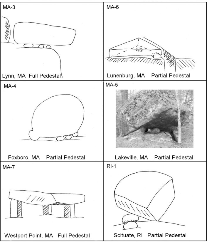
1- Montville (west side of lower Thames River SE part of state): Full Pedestal boulder on three support stones placed on exposed bedrock. Two support stones are small. One support stone is a large triangular slab with point jutting outward. Triangular slab is propped up by a small stone under its narrow pointed end. The actual location within the town is not stated. This town has three stone chambers and a large cairn site. (Mavor & Dix, 1989: 111)
2- Brooklyn (east-central Route 6 & 169 west side of Quinebaug River): Full Pedestal boulder called “Tripod” because of three support stones placed in a triangle formation under the boulder. Boulder is on exposed bedrock. (Whittall, 1977: 55)
New York
1- North Salem (Southeast part of state on southwest border of Connecticut): Full Pedestal boulder on the ground with five support stones. Each support stone has a conical shape with pointed top. Pedestal boulder rests on pointed tops. (Trento, 1997: 196)
2- Stephentown (East central part of state in Taconic Range on west-central border of Massachusetts): Full Pedestal boulder on the ground with five support stones. Each support stone has a pointed top. Pedestal boulder rests on pointed tops. (Rothovius, 1979: 35)
The towns of North Salem and Stephentown are east of Hudson River and on border to two other states. There are no apparent natural features at either state border. There is at least a fifty mile distance between the two pedestal boulders yet each one is remarkably similar to the other. The two features have what is called a regional style. Both were set up on five support stones with pointed tops and placed the on ground.
New Jersey
1- Kinnelon (North part of state): Full Pedestal boulder with three support stones on exposed bedrock. Across top of this rectangular shaped boulder is a prism-like triangular bar p rotrusion. In the northern part of the state there are stone cairn sites. (Trento, 1997: 270)

Discussion
The pedestal and perched boulders presented in this section have specific patterns that were repeatedly used and therefore can be tracked. Those patterns occur in number of support stones, shape of support stones, shape of boulder, whether or not boulder makes contact with bedrock, bedrock verses ground, and slab verses chunky. Patterns are interchangeable from boulder to boulder in any combination. This is a limited study but it indicates regional patterns exist and ideas diffused throughout the northeast.
New York’s east border has full pedestal boulders on the ground this is not seen anywhere else. These same two boulders have five support stones with pointed tops. This creates three different patterns repeated in each feature in a regional area. The regional area is on a north-south orientation.
Southeast New Hampshire and northeast Massachusetts each have an inverted perched triangular boulder. One is on south side of Merrimack River (Newbury, MA) and other is inland north of the river (Sandown, NH). The boulders are approximately twenty-five to thirty miles distant from each other and on a north-south orientation.
Central and south central Massachusetts partial pedestal boulders make contact with the bedrock. That is one of the support points is the actual boulder on bedrock with addition of support stones. The number of support stones varies from one to three. This idea of boulder in contact with bedrock is also seen in Rhode Island which abuts southeast Massachusetts.
Rhode Island’s boulders have unique features. One in Scituate has five support points without any support stones. The underside of boulder has concave surfaces with protruding surfaces (5) used for the support points. Five is same number of support stones used in the New York full pedestal boulders. In Massachusetts the Lakeville boulder has a concave underside. Another Scituate boulder has a thick slab-like triangular shape. It wass placed in a semi-vertical position, is supported on one side by a stone and makes contact with base on what looks like one end of apex. Other end of apex is raised off the bedrock. This creates an inverted triangle like in Massachusetts and New Hampshire but does not place the boulder on its inverted side. It created a partial pedestal boulder instead of a perched boulder. Two of Rhode Island’s boulders have fractures that create thick layers of intact stone.
Triangles are the most versatile feature. They are seen in triangular configurations of support stones, in the actual shape of the boulder or slab, and in a protrusion on the boulder. Usage shows they were set up in horizontal and inverted positions with one exception in an upward position. Triangles were incorporated into supports, the actual boulders and in conjunction with additional perched boulders.
See NH2, MA1, and RI1 for three inverted triangles. Dogtown’s pedestal boulder in Gloucester, MA has its support stones arranged in a triangle shape. The triangle shape is repeated in the two additional perched boulders on bedrock that accompany the full pedestal boulder. In Lunenburg, MA (west-central) a thick slab with a triangular shape was split off and moved over to the edge of a ledge beside a fissure. This triangle is horizontal has two support stones and makes contact with pointed end of boulder on the ledge. Contact with ledge equates to boulders in central and south central Massachusetts and Rhode Island. One Rhode Island example is a triangle that also has a pointed end in contact with bedrock. Fissure in association with boulder equates to south central MA at Lakeville. In Montville, CT (southeast) a thick slab with a triangular shape was used as a support stone for a rectangular shaped full pedestal boulder. Further to the south in northern New Jersey the triangle shape shows up on top of a rectangular boulder. Triangle on this boulder is a three sided prism shape across width of top with pointed side up and is oriented north-south.
Rectangles are another shape that was utilized. Kinnelon, NJ, Lynn, MA and Montville, CT each have one with this shape.
Some patterns appear to be confined to specific geographical areas. Others such as the triangle are wide spread but show regional differences. There is a high concentration of partial pedestal boulders in contact with bedrock between southern MA and Rhode Island but this feature is not limited to that geographical area. North-central MA and northeast MA each have an example of this style. So far two fissures have been found in association with partial pedestal boulders one in north-central MA and other in southeastern MA. Each of these has the boulder in contact with bedrock. As of this study (2-15-06) Massachusetts has the highest number with seven and Rhode Island is next with four.
Of the twenty pedestal and perched boulders presented here six are either in direct association with stone cairns and other stone structures or are in vicinity of stone structure/cairn sites. Two are in close proximity to houses. Knowledge of what is in the vicinity of the other twelve is lacking.
Full Pedestal & Partial Pedestal Bouders - Interpretation
Two factors occur with the pedestal boulder. One is the boulder is raised above a bedrock base or in a few rare cases off the ground. Second many pedestal boulders have either three support stones and/or some form of triangle that is integrated into the feature.
Triangles of any design have one usage to block out uninvited spirits. The use of triangles whether the shape is made up of three stones placed in a triangle shape, a solid triangular shaped stone or an area enclosed by a stone wall in the shape of triangle it does not matter, each one had the same protective function. Triangles were used when a specific spirit(s) was invited into a ceremonial area or feature for a ceremony. The triangle allowed the invited spirit to enter but at the same time kept all other spirits out of the feature or structure.
Bedrock is a common factor with most pedestal boulders. Bedrock although its surface is exposed is primarily underground in the Underworld. Bedrock whether it has an opening in the form of a fissure or crack, or it is solid, is a conduit to the Underworld. Raising a boulder fully or partially creates an enclosed and restricted space. The open space underneath a pedestal boulder becomes a niche and the bedrock a portal. This theory was derived from the Lunenburg, MA pedestal boulder, from two offering walls at America’s Stonehenge, North Salem, New Hampshire and from the Gloucester, MA pedestal boulder.
Proof of a fissure utilized as an Underworld spirit portal comes from America’s Stonehenge site. The fissure has a short triangular stone placed deep inside. On top of the short triangle was placed two standing stones one is a vertical rectangle and other is a vertical rectangle with a triangular top. This particular fissure is an Underworld spirit portal protected by the triangles and rectangle.
At Lunenburg, MA an ex-large triangular slab was raised up on two support stones next to a fissure (MA-6). On opposite end (pointed end) the slab rests on bedrock. The fissure is an Underworld spirit portal. The partially raised triangular stone slab is a niche. Niches with large flat slabs laid flat and raised a few inches off the bedrock were documented at America’s Stonehenge. (Gage, America’s Stonehenge Deciphered, 2006) A perishable offering was placed in the niche to call forth the Underworld Spirit. The spirit was called forth to be at a ceremony held at this location. There are other features that go with the site. (For a write up of the features see Manitou.)
At America’s Stonehenge the Offering Wall at the summer solstice sunset was built upon solid exposed bedrock. There are no features in the bedrock other than the fact the bedrock is underground in the Underworld with its top exposed to the surface. The stone offering placed in the wall was given to the Underworld Spirit. In this case, the bedrock became a conduit to the Underworld, an access point. The second example of an offering wall on bedrock occurs at the Winter Solstice Sunset Ceremonial Area. In this wall a piece of bedrock was removed to create an L shaped opening. L shaped openings are spirit portals. This portal is embedded in bedrock directly in contact with the Underworld. The stone offering was therefore directed to the Underworld Spirit who participated in the sunset ceremony. (Gage, America’s Stonehenge Deciphered, 2006)
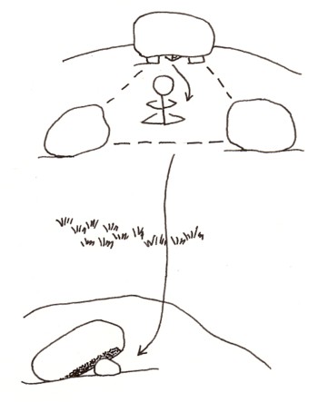 In Gloucester, MA at a historic place called Dogtown there are three large boulders approximately three feet long by two to three feet high. Two are perched boulders set directly on the bedrock and one is a pedestal boulder raised on three support stones. The three boulders are set up in a triangular shape and form an enclosure. The three support stones that raise the pedestal boulder were placed in a triangle shape. The pedestal boulder created a niche within the open space underneath it and the enclosed/exposed bedrock created a spirit portal. This is a combination feature of niche and spirit portal. The three support stones forming a triangle were used to block out uninvited spirits from entering the niche and portal. The triangular enclosure was also used to block out uninvited spirits. For the ceremony held here a perishable offering was placed in the niche (raised area underneath the boulder) and used to call forth the Underworld Spirit. In this case, the Underworld Spirit was called forth into the triangular enclosure created by the three large boulders. Inside the enclosure one or two leaders gathered to hold a ceremony with the spirit.
(Right) Dash line indicate the enclosure like space created by the three boulders. Arrow show route that spirit travels.
The people probably interacted with the spirit. In addition to the pedestal boulder unit at Gloucester there is a partial pedestal boulder nearby. The partial pedestal boulder has no associated features except it is on the same hilltop as the fully pedestal boulder. In this case, the full pedestal boulder was used to call forth Underworld Spirit from the Underworld and the partial pedestal boulder was used by the spirit to re-enter Underworld. This same scenario is seen at the Small Underworld Spirit Ceremonial Area at America’s Stonehenge. (Gage, 2006: pp 202-4)
Conclusion
Full pedestal boulders and partial pedestal boulders need to be evaluated individually. Raising a boulder fully or partially creates a niche, a spirit portal to the Underworld or combination of the two features, a niche/spirit portal. The spirit portal can be an exit or an entry. Look for protective symbolism in the form triangles or three support stones in the shape of a triangle. The protective symbolism will indicate a spirit was present. Lack of protective symbolism as in the case of the partial pedestal at Gloucester does not immediately indicate the lack of a spirit. Look for other features to see if a spirit was present like a split boulder or fissure, and cairns. Some pedestal boulders have lost their accompanying stone structure sites like the one in Lynn which is now in the middle of a suburban neighborhood.
The recurring triangles are not a natural occurrence. The triangles are too common and numerous to be natural. These are man-made pedestal boulders. However, pedestal boulders do occur naturally. Naturally occurring pedestal boulders have irregularly placed support stones, and variations in the number of support stones. An example of naturally occurring pedestal or partial pedestal boulders is seen at Agassiz Rock in Manchester, MA. At this site there are many perched boulders scattered about near the partial pedestal Agassiz Boulder. There are no man-made stone structures. That suggests the site was not used by Native American’s to hold a ceremony. This does not mean every natural pedestal boulder was not used or considered sacred by Native Americans. There may be other cases where a natural pedestal boulder may have been used. If man-made stone features are in association with a natural pedestal boulder then it means it was sacred. The important thing is to be able to distinguish between what is a sacred site and what is not.
Perched Boulders: large or ex-large boulders placed on bedrock
For a boulder to be considered a perched boulder feature is difficult in most cases to determine. Glaciers naturally placed boulders on the ground and bedrock when they melted. Some naturally placed perched boulders were considered sacred. Other boulders may have been moved into place like the two perched boulders in Dogtown in Gloucester, MA. In Rhode Island there are reports of two perched boulders where one boulder is repeatedly smaller than the other boulder. This is a definitive pattern that can be traced. It is not a natural occurrence to have this combination show up repeatedly. Its use and purpose are unknown.
Bibliography
Cahill, Robert
1993 New England’s Ancient Mysteries. Salem, MA: Old Saltbox Publishing Inc.
Gage, Mary
2006, America’s Stonehenge Deciphered. Amesbury, MA: Powwow River Books.
Mavor, James & Byron Dix
1989 Manitou: The Sacred Landscape of New England’s Native Civilization. Rochester, VT: Inner Traditions.
Rothovius, Andrew
1979 “The Problem of the North American `Dolmen’ (Boulder Placements or `Perched Rocks’)” NEARA Bulletin vol. 14 no. 2 pp. 32-36.
Trento, Salvatore
1997 Field Guide to Mysterious Places of Eastern North America. New York, NY: Henry Holt and Company.
Whittall, James II
1991 “An Inscribed Stone on the Great Trail: Hampton, Connecticut” Early Site Research Society Bulletin vol. 18 no. 1 pp. 53-55 (October 1991)
 2005-2008, James E. Gage & Mary E. Gage. All Rights Reserved.")